A History of Roads In Virginia
Produced by the Virginia Department of Transportation Office of Public Affairs, 1401 E. Broad Street, Richmond, VA 23219.
© 2002, Commonwealth of Virginia
Early Virginia transportation ![]()
Early Loudoun transportation »
Waterways and crude paths met the transportation needs of the Indians and early settlers. The colonists discovered a crude network of paths made by Indians.
SAVING LOUDOUN'S ROADS
Loudoun County is home to Virginia’s largest network of rural roads. Many of these miles of byways pre-date America, carved out by early settlers. Learn about these roads and the stories they tell. Visit Loudoun's Rural Roads
The word "road" probably was derived from the Middle English "rode," which meant a mounted journey. The companion word "highway" is believed to have come from the practice, hundreds of years ago in England, of building main roads higher than the adjacent land by throwing earth from side ditches toward the center, as the ancient Romans had done. Because they were higher, they were called "high wayes." This is a story of their development in Virginia.
The Virginia settlers, who arrived at Jamestown Island aboard three small ships on May 13, 1607, had little need for a road system. Barely more than a hundred in number, their first concerns were disease, hunger, shelter, and protection from the often hostile Indians who had lived on the land for generations. In those first rigorous years, survival itself demanded the full energy of the colonists in the wilderness.
The waterways were there for transportation-- the great rivers that emptied into the Chesapeake Bay and that were to become known as the James, the York, the Rappahannock, and the Potomac.
Colonists carved roads through the Virginia wilderness.
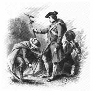
As the colonists hunted for food and cautiously began exploring the forest, they discovered a crude network of paths made long before by Indians and wild animals. The colonists used these, and many of the paths were to shape the Virginia road pattern for years to come.
The settlers also found roughly built bridges formed by the Indians from tree trunks and limbs, which the settlers at first believed to be Indian-planted traps rather than bridges. By 1610, with new arrivals from England, the colony numbered some 210.
The Rhoade along the River Bank, probably a former Indian path, was used to haul supplies from the ships to the Jamestown Fort.
The Greate Road appears to have been Jamestown's main street, and it was of early commercial importance. It crossed the isthmus connecting the island with the mainland at Glass House Point, where in 1608 and for a brief period afterwards, glass was manufactured for export. Faint traces of the road are evident today at Glass House Point.
Eventually, the Greate Road extended on the mainland to Middle Plantation, a settlement to become known as Williamsburg and destined to be the capital of the Virginia colony and the hub of the colonial road system.
The first bridge recorded as having been built by the English settlers was constructed in 1611 at Jamestown Island. It wasn't really a bridge, but a wharf about 200 feet long from the bank of the James to the river channel, where the settlers docked their ships. The colony's first agricultural crops raised for export were rolled to these ships.
John Rolfe had begun experimenting with the cultivation of tobacco in 1612 and two years later exported a shipment to England. In less than 20 years, tobacco exports had reached 500,000 pounds annually; tobacco would remain the foundation for the Virginia economy throughout the colonial period.
Inevitably, the success of the tobacco crop was to influence the colony's transportation needs as well.
The tobacco fields spread on the mainland, and a number of the old Indian paths became tobacco rolling roads. The name came from the practice of packing the harvested tobacco in barrels called hogsheads and rolling them to the wharves, frequently a distance of miles. The rollers ordinarily tried to follow the high ground and avoided the fords, or shallow stream crossings, because water leaking through the barrels would damage the tobacco. The practice of following the old paths and branching off from time to time on higher ground accounts for many of the early meandering country roads.
After two decades, the colony's population was near 5,000 and growing. The frontier had been pushed well beyond its original boundaries, and while much of the settlers' travel was still by boat, an increasing proportion was on land.
America's First Road Law
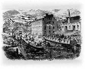
The James River and the Kanawha Canal played an important role in increasing communications and commerce between commercial centers and rural areas of the state.
The need for improving roads to better serve the social and economic life of the colony was among the matters facing members of the House of Burgesses as they met in Jamestown in September 1632.
Before adjournment, they had passed the first highway legislation in American history, an act providing, in the language of the day, that, "Highwayes shall be layd in such convenient places as are requisite accordinge as the Governor and Counsell or the commissioners for the monthlie corts shall appoynt, or accordinge as the parishioners of every parish shall agree."
The first legislation also required each man in the colony to work on the roads a given number of days each year, a custom dating at least from the feudal period of the Middle Ages in England, or to pay another to work in his place. This labor law, to remain in effect for more than 250 years, provided the main source of workers for road and bridge construction.
Twenty-five years later, probably in March 1657, the colony's basic road law was broadened to provide "that surveyors of highwaise and maintenance for bridges be yearly kept and appointed in each countie cort respectively, and that all generall wayes from county to county and all churchwaies to be laied out and cleered yearly as each countie cort shall think fitt, needful and convenient, respect being had to the course used in England to that end."
In 1661, the surveyors were empowered to select locations for roads, choosing "the most convenient wayes to Church, to the Court, to James Towne, and from County to County."
By the end of the 17th century, many miles of primitive roads threaded throughout Tidewater Virginia. The colony's population had reached 70,000. While horseback was the most frequent means of overland travel, horse-drawn carts became more numerous, and some carriages and coaches gradually appeared.
In 1705, the legislature passed a new road act providing for "making, clearing, and repairing the highways and for clearing the rivers and creeks... for the more convenient traveling and carriage, by land, of tobaccos merchandise, or other things within this dominion . . . "
The new road act provided for further extension of the road system and required that the roads "be kept well cleared from woods and bushes, and the roots well grubbed up, at least thirty feet broad." The new law also provided for skilled labor to erect bridges larger than could be built by the local surveyors, and when such a bridge was to cross a county line, its cost would be divided "proportionable to the number of tithables in each county."
Other road laws came quickly in the early years of the 18th century. Owners of mill dams were required to provide a 10-foot passage on dams and spillways; it became mandatory for a county in which an iron furnace was operated to provide "good roads to be laid out and made from such works to the nearest place upon some navigable river or creek"; establishment of public ferries was authorized by the legislature.
In 1716, Alexander Spotswood, regarded by many as perhaps the best of the colonial governors, led his "Knights of The Golden Horseshoe" up the summits of the "Great Mountains," the Blue Ridge, and looked down in amazement at the splendor of the Shenandoah Valley. Spotswood, a former soldier, recognized that settlement of the valley could help protect eastern Virginia from hostile forces.
It was in the next quarter-century that the valley and much of the Piedmont, the rolling country between the mountains and Tidewater, were settled by pioneers moving inland and by many others who came down into the valley from Pennsylvania and New Jersey.
Extending north and south through the valley was a relatively good Indian path, called by various names including the Appalachian Warriors' Path and the Shenandoah Hunting Path. By the mid- 18th century, it had been developed into the Great Wagon Road, which eventually led from Pennsylvania southward through the valley and on to Georgia.
Toward the southern end of the valley, the Great Wagon Road separated into two branches near Big Lick, later to become Roanoke. While one branch left the valley and went due south, the other continued west and crossed Cumberland Gap through the Allegheny Mountains at what now is the junction of the Virginia, Kentucky, and Tennessee borders. After Daniel Boone and a band of frontiersmen cleared a path into Kentucky about 1775, the western branch became known as the Wilderness Road , and it was to become the main pioneer route along which traveled the first waves of the great migration to the West.
East of the mountains, two principal routes led from where Richmond stands today deep into the interior. One was a path to the settlements that were to become Lynchburg and Roanoke, a course now followed approximately by U.S. Routes 60 and 460. The other was the Three-Chopt Road or Three-Notched Road to Albemarle, where it connected with another path leading across the mountains at Afton and into the valley. Its name came from the way it was marked to guide travelers, with notches cut on the trees.
In his "Notes on the State of Virginia" in 1785, Thomas Jefferson described the approach to handling road matters. "The roads are under the government of county courts, subject to be controlled by the general court. They order new roads to be opened wherever they think them necessary. The inhabitants of the county are by them laid off into precincts, to each of which they allot a convenient portion of the public roads to be kept in repair. Such bridges as may be built without the assistance of artificers (skilled workers or craftsmen), they are to build. If the stream be such as to require a bridge of regular workmanship, the county employs workmen to build it at the expense of the whole county. If it be too great for the county, application is made to the General Assembly, who authorizes individuals to build it and to take a fixed toll from all passengers, or gives sanction to such other propositions as to them appear reasonable. Ferries are admitted only at such places as are particularly pointed out by law, and the rates of ferriage are fixed."
Turnpike Era
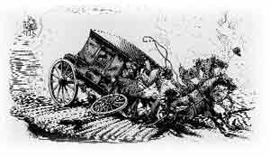
Much manual labor was the requirement for building and maintaining early roads.
Road building in the latter stages of the 18th century and much of the 19th century was marked by the development of many turnpikes or toll roads. As Jefferson observed, toll financing provided a means of building highway facilities for which there was a need but which were too complex and costly to be constructed by the counties alone.
For the most part, Virginia counties were impoverished and exhausted from their contributions of men, supplies, and other resources to the Revolutionary War. The turnpike era offered a new way of meeting road needs.
The turnpike got its name from its toll gate. When first designed, the gate was a turnstile consisting of two crossed bars pointed at their outer ends and turned on a vertical bar or pole.
In 1772, the Virginia legislature cleared the way for what probably was the first toll road in America, when it authorized Augusta County to build a highway over the mountain between Jenning's Gap and Warm Springs and to establish a toll gate. The road, as outlined by the legislature, was to be financed with 300 pounds advanced by the colony and 900 pounds raised by a lottery. Revenue collected from travelers was to be spent for the upkeep of the road and "towards building... housing for the reception of the poor sick resorting to the said springs."
In 1785, five years after Richmond had become the state's capital, the legislature appointed a commission to erect toll gates on existing roads in the Alexandria area to increase road revenue. The Fairfax and Loudoun Turnpike Road Company was chartered in 1795 to construct an improved road between Alexandria and Little River in Fairfax County. It accomplished little, however, and was followed in 1802 by the Little River Turnpike Company which, in 1811, completed a 20-foot- wide turnpike extending west from Alexandria for about 34 miles. It operated as a toll road for nearly a century, and its completion touched off construction of many turnpikes in Virginia by the time of the Civil War.
Virginia's population by 1800 had climbed to 880,200, with settlers in most of the major regions that make up the present state. This growth and expansion led the General Assembly in February 1816 to establish the nation's first state board of public works and to create a fund for internal improvement. The board, with the governor serving as president, was empowered to appoint a "principal engineer" for the state, and it existed until 1902. Its formation coincided with the beginning of the nation's canal era.
The board was responsible for chartering, finding, and supervising internal improvements. The fund, amounting to more than a million dollars, was created to transfer shares, owned by the state, in the stock of the Little River Turnpike Company, the Dismal Swamp, Appomattox, Potomac, and James River Canal companies and in two banks. Money in the fund was to be used to match private capital in financing improvements.
The office of the principal engineer provided important resources for the location, design, and construction of transportation facilities in Virginia for years to come. The first principal engineer, Laommi Baldwin, Jr., held office from 1816 until 1818, when he resigned. Baldwin was succeeded by Thomas Moore, who served until his death in 1822. Moore then was followed by Claudius Crozet, an engineer who was to have deep influence on Virginia transportation.
Crozet had been a French artillery officer under Napoleon Bonaparte before coming to America. He also had been a distinguished teacher at the United States Military Academy at West Point.
In Virginia, he served two terms as principal engineer, 1823-31 and 1838-43. The break in his service reflects the continuing dilemma of those faced with the responsibility for applying the results of a rapidly changing technology to large-scale public works.
One of the major efforts supported by the board of public works was the James River and Kanawha Canal, which was intended to improve communication and trade between the populous and politically powerful eastern Virginia and the comparatively isolated western regions of the state. Development of the canal had started in 1785, but it had not advanced as rapidly as its promoters had hoped.
A new and serious obstacle to its success appeared in 1829, when the Stourbridge Lion, an early locomotive, was imported to the United States from England. A year later, Crozet suggested that in view of this exciting new invention, a steam railroad would be preferable to the canal to link east and west. It was a bold idea indeed, because until then no railroad using steam locomotives had been operated in this country. Moreover, it was a controversial idea; powerful forces in the state wanted completion of the canal.
Largely as an outgrowth of the controversy, the board of public works was reorganized by the legislature in 1831 with a requirement for annual legislative approval of the principal engineer. In addition, Crozet's salary was reduced from $3,500 to $2,500. Crozet resigned and spent the next six years in Louisiana.
Crozet returned to his former position in Virginia at the beginning of 1838, and although his position favoring railroads over canals ultimately proved correct, the controversy remained. It ended in 1843 with an act stating "that the office of chief engineer of the state be and the same is hereby abolished."
Shortly afterwards, Crozet became principal of Richmond Academy in downtown Richmond, but in 1849 he responded to the pleas of his former opponents and returned to engineering to direct construction of a rail road through the mountains. The community of Crozet in Albemarle County is named for him.
During calmer days as state engineer, Crozet also was responsible for building highways through the mountains, as well as in other regions. One of the principal roads was the Northwestern Turnpike, which emerged in 1827 as Virginia's bid for the profitable trade of the territory northwest of the Ohio River.
Legislation incorporating the turnpike authorized subscriptions from the townspeople of Winchester, where the road was to begin, and of the other communities along the way. But its authors chose a route to serve the most populous towns without much regard for the difficult terrain. Little progress was made.
In 1831, the legislature provided for a company, with the governor as president of its board of directors, to borrow money and construct the turnpike with a minimum width of 12 feet "from Winchester to some point on the Ohio River to be situated by the principal engineer."
The turnpike eventually reached the Ohio River, and its gentle grades and alignment, developed largely under Crozet's direction, made it one of the good roads of its day. The course it followed is largely that used today by U.S. Route 50.
The Valley Turnpike was another important 19th century road developed during this period. Incorporated in 1834, the Valley Turnpike Company was authorized by the legislature to improve the route between Winchester and Harrisonburg -- part of the ancient Indian Warriors' Path and the Great Wagon Road followed by the early pioneers. The improvements were financed largely with $25 shares sold to private citizens and were completed in 1840.
Early Paving Methods
Plank roads were introduced from Canada in the 19th century, sometimes with jarring results.
While most roads remained dirt and in miserable condition, the turnpikes, relying on income from travelers for their existence, were provided in most instances with gravel, broken stone, wood, or macadam surfaces.
The old Manchester Pike near Richmond had been surfaced with gravel in 1808 and was recognized as the first "artificial" or paved road in the state. The widely used macadam surface was named after its developer, John Loudon McAdam, a Scottish-born engineer who began building roads in England in the early 19th century. McAdam is credited as the first to recognize that dry soil itself generally would support the weight of traffic and that pavement was necessary only to provide a smooth riding surface and to ensure dryness.
The macadam pavement consisted of crushed rock packed tightly into thin layers, with a top surface of sand or finely crushed stone rolled to provide a wellbound surface resistant to the penetrating damage of rain, ice and snow. McAdam generally specified a uniform thickness of seven to 10 inches for the finished road, although some ranged at least to 18 inches in thickness.
The specifications for one macadam road provided for the first layer of stone to be "cast on with a shovel to a depth of six inches, after the manner of sowing grain." It was to be compacted with a cast-iron roller, "prepared with a box, or a cart bed, to carry two or three tons of sand" and rolled until "sufficiently solid and compact to receive the second layer." After dressing the surface "with a rake or otherwise," the second layer, three or four inches thick was to be "put on, rolled, and prepared in all respects as the first stratum was, until in a state of firmness and solidity, proper to admit the third or last stratum, which can then be put on, and the surface raked and dressed to such shape and form as may be required, and also rolled until satisfactorily compacted.
Part of the Lynchburg-Salem Turnpike was the first segment of road to be macadamized in Virginia. The Valley Turnpike and the Southwestern Turnpike, between Salem and Seven Mile Fork near Marion, were others.
Wooden pavements were also used widely in the turnpike era, perhaps naturally, since standing timber was abundant over much of the state.
"Corduroy" roads were built by placing small logs side by side along a cleared path and covering them with dirt for smoothness. The "plank" road was introduced in the United States from Canada, where some 500 miles were laid between 1834 and 1850. A typical plank road had a single track about eight feet wide, with the planks placed crosswise. Later, they were inclined slightly to allow rainwater to drain.
By the mid-19th century, the railroads Crozet had favored were handling much of the long-distance movement of passengers and freight. This posed a new problem for the turnpikes, many of them already financially troubled. The railroads gained such great popularity that apathy developed toward road improvements. For the turnpikes, it meant reduced use and revenue. For other roads, it meant that many remained little more than dirt paths, impassable after heavy rains or during winter thaws and raising choking clouds of dust at other times.
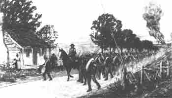
With the outbreak of the Civil War in 1861, roads and railroads became immensely important to both Confederate and Union armies. The transportation arteries often governed the outcome of battles. The armies fought over them, guarded them, rebuilt them and constructed new ones. Food, clothing, medical supplies, guns, ammunition, and men moved by road and by rail.
In September 1861, Gen. Robert E. Lee, writing from a mountain encampment to Gov. John Letcher, said, "Our greatest difficulty is the roads. It has been raining in these mountains about six weeks. It is impossible to get along. It is that which has paralyzed all our efforts."
Two years later, then commander of the Army of Northern Virginia, Lee wrote, "It has been raining a great deal . . . making the roads horrid and embarrassing our operations." Some wagons simply broke down on the road from the mud and rocks.
Other military commanders on both sides could tell similar stories of how road conditions often hindered their operations.
The ravages of Civil War campaigns left many of Virginia's roads in ruins.
Poor to begin with, the roads and bridges were damaged and destroyed as the armies fought over them repeatedly. The company that operated the Valley Turnpike reported that its revenue collections were negligible because "of the army destroying bridges, injuring toll houses, and we are getting very little tolls."
For most of the turnpike companies, the war was the final blow from which they could not recover, and many passed from private to county ownership. Toll collections on most of the turnpikes never had been enough to pay operating and maintenance costs or to do much toward retiring the indebtedness, and the extensive but financially weak turnpike era was nearing an end.
A few toll facilities, the Little River and Valley turnpikes among them, somehow managed to recover sufficiently from the rages of war to remain in operation into the early 20th century. But a constitutional amendment in 1874 decreed that the state government could no longer invest in turnpike company stock. The risk was too great.
After the war, the state's board of public works turned mainly to matters other than roads, and in the counties there developed a widely varying patchwork of road development practices. Twenty-five years after the war, Virginia's roads were far worse than when the war began.
This was true despite the fact that, in the Reconstruction period, the General Assembly enacted much road legislation. The problem was that much of it was confusing and meaningless, and sometimes humorous. One law made it illegal to drive or lead a bear on a public highway, and another set a fine of $5 for a pedestrian who crossed a bridge at a pace greater than a walk.
A series of events late in the 19th century and early in the 20th century, however, were about to revolutionize man's mode of travel.
Auto Age Begins
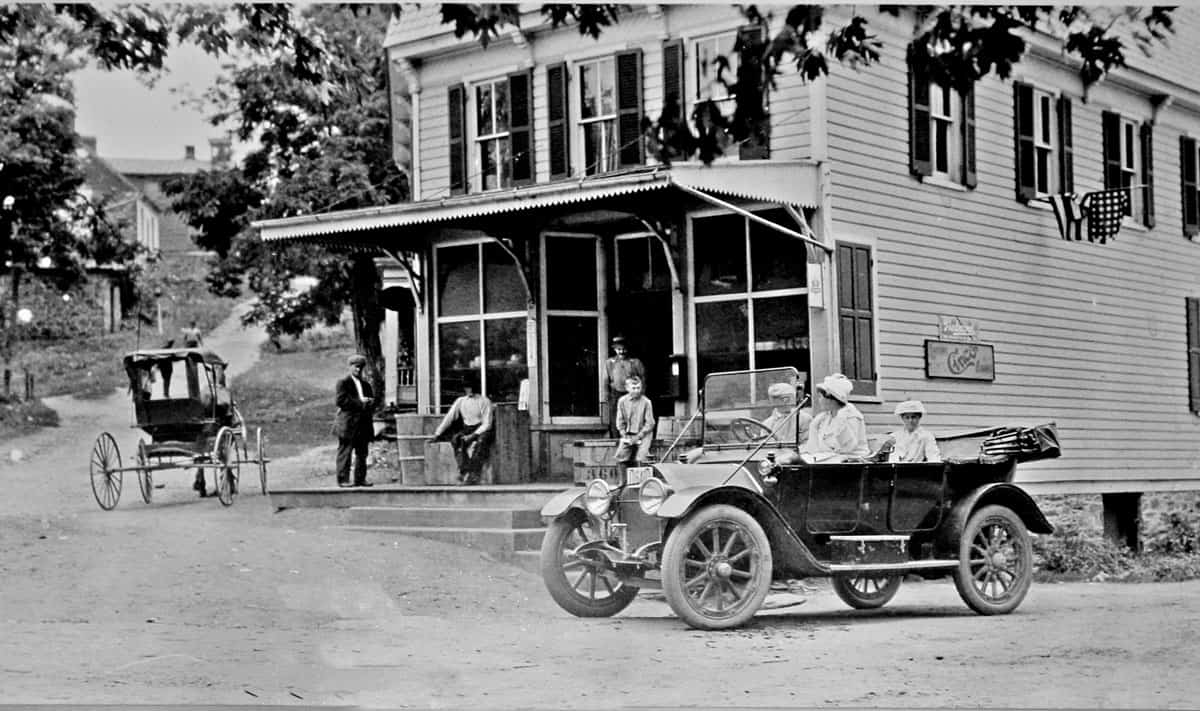
One of the first automobiles in Waterford Virginia driving by the Corner Store.
In Springfield, Mass., in September 1893, what generally is accepted as the first American gasoline-powered automobile was given a short road test by its builders, brothers Charles E. and J. Frank Duryea.
That same year in Washington, the Congress established the United States Office of Road Inquiry, directing the Secretary of Agriculture "to make inquiries in regard to the system of road management throughout the United States," to investigate methods of road building and to assist in disseminating information about the nation's roads.
Good roads societies were organized in many states and in Virginia, this movement dates at least to 1894. It was then that the Young Business Men's League of Roanoke took leadership in forming the Virginia Good Road Association. Local meetings and statewide conventions were held, and enthusiasm grew swiftly.
In September 1895, the Duryea brothers established the first American company to manufacture gasoline-driven cars, the Duryea Motor Wagon Company. In 1904 the Ford Motor Company produced 1,695 cars, and by 1907 had increased its production to 14,887.
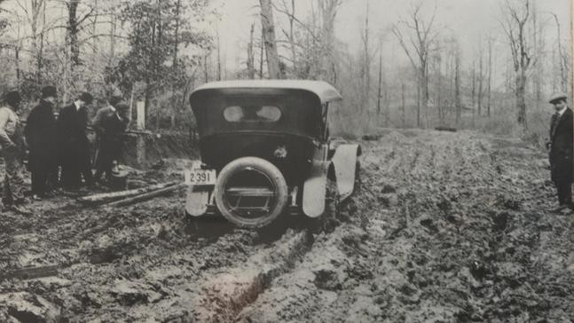
Circa 1929: A muddy lane in Western Loudoun County. (Photo Courtesy of Virginia Department of Transportation)
The last decade of the 19th century was called the Gay '90s, and the daring new mobility was a part of the mood. What is believed to have been the first automobile of any kind operated in Virginia was driven along Norfolk streets in 1899, powered by kerosene. Eleven years before that significant event, the world's first commercially successful streetcar system had begun in Richmond. The state's population had grown to 1,854,184, and while the population was about 85 percent rural, the capital of Richmond could count 85,000 residents. Throughout Virginia, as throughout the nation, the public's delight with the automobile was mounting by leaps and bounds. But in most places, the roads weren't ready for this "horseless carriage."