Yardley-Taylor Map of Loudoun County, Dated 1853
More about the Yardley-Taylor map »
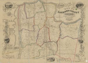
The first detailed map of Loudoun County — or of any part of the Virginia Piedmont or Northern Virginia — was surveyed and drawn by Yardley Taylor in 1852-53. Taylor's 36-by-51-inch "Map of Loudoun County, Virginia, from Actual Surveys" was printed on linen in muted red, yellow and green and black. The worth of Taylor's map rests in its detail. He identified hundreds of owners or occupiers of residences and 77 water-powered mills. He gave the denomination for each house of worship, which, as a Quaker, he designated as "Meeting Houses."
Read the accompanying booklet, Memoir of Loudoun County to Accompany the Map by Yardley Taylor 1853.
1853 Yardley Taylor Map of Loudoun County (Library of Congress) )
See the full image (A large file)