With 'The Park,' County's Growth Battles Were Just Beginning
The beginings of Sterling Park, Virginia in 1961
by Eugene Scheel
A Waterford historian and mapmaker.
June 16, 2002
With additional comments by Marvin T. Broyhill III
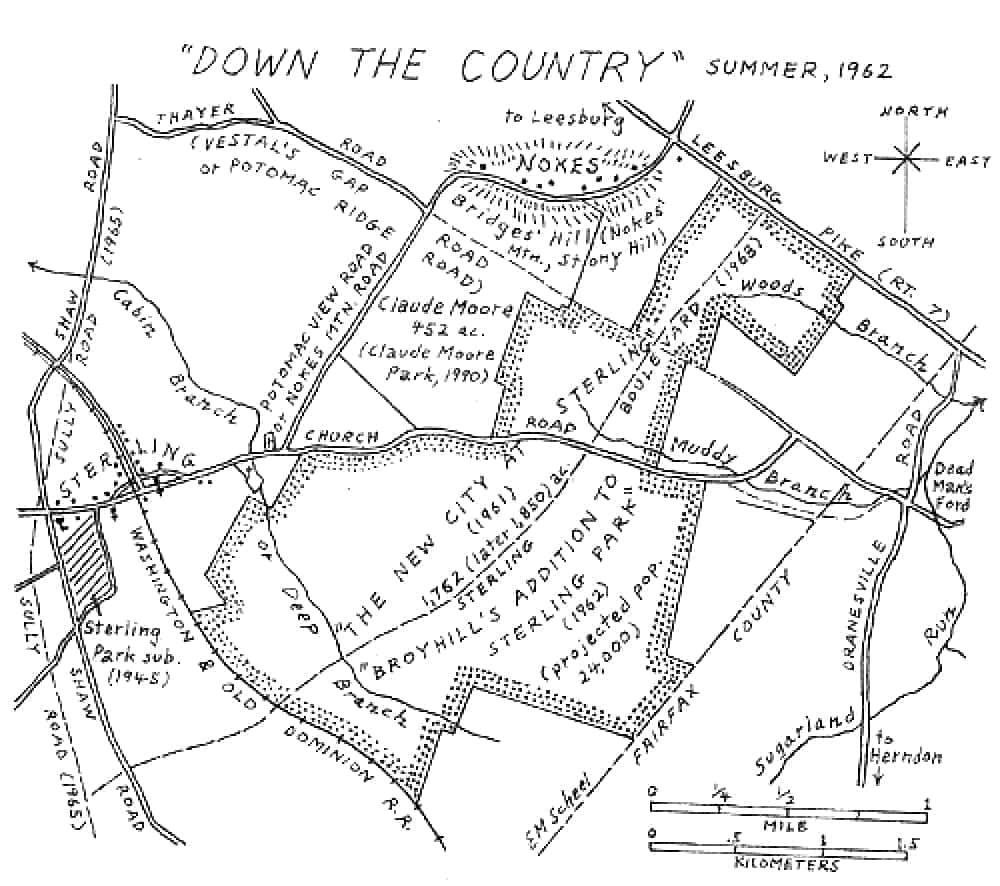
Sterling Park 1962
"You might say we lost the big one," former Loudoun supervisor J. Terry Hirst mused as we talked about the long-ago controversy over Sterling Park. Forty years ago this Friday, the Board of Supervisors voted 3 to 2 to approve the first planned community in Loudoun County.
Hirst, then supervisor of the old Mount Gilead District, voted no, and in 1976 he was telling me about the county's battles against "outsiders," his catchword for powers not native to Loudoun.
In early 1962, large farms made up the 1,762 contiguous acres of what would become Sterling Park. Bordering on Route 7, then called the Leesburg Pike, was Jesse Hughes's dairy farm. He had come to Loudoun in the early 1900s and had been a longtime head of the county's Democrats.
Comments from M.T. Broyhill Sr's Grandson
My grandfather, Marvin T. Broyhill Sr, was not actively involved in the Sterling Park Project. "M.T", as he was always called was born in Wilkes County, NC. in 1888. In 1951, he built a huge house on North Vermont Street in Arlington. His son Joel lived next door and we lived on the other side of Joel. In 1959, MT was 71 and he retired and moved to Florida. I know that first hand because I remember the sale of his house.
Sterling Park was conceived and started by my father, Marvin T. Broyhill Jr. He discussed step-by-step progress of the project at the dinner table.
In 1914, DuPont announced that it had purchased the Hopewell Plantation![]() , not far from City Point Virginia. The country was undergoing a depression and the mass construction project attracted workers from all over the east coast. City Point (now Hopewell) grew from 650 people to over 50,000 within six months.
, not far from City Point Virginia. The country was undergoing a depression and the mass construction project attracted workers from all over the east coast. City Point (now Hopewell) grew from 650 people to over 50,000 within six months.
MT's brother Ruel went to Hopewell and wrote home about the opportunities. Soon he was joined by his parents and siblings. Granddad was very successful in real estate during the World War I building boom, but when the war ended, the population dropped to around 3,000 and he lost a great deal of money that was invested in land he could not sell.
He began building prefabricated Sears home (Sterling Park was the not the first experience with these.). I don't know exactly how many but they are now listed on the historic register and the Hopewell Tourist office publishes a driving tour of some of the best known. Granddad was wiped out again by the depression. He and his brothers survived by building wherever they could. Projects included a motel in Florida and apartments in Front Royal.
In 1937, MT, following the events in Europe, predicted there would be another war and that it would result in the tremendous expansion of the federal government and all of those people would need homes. He moved his family to Arlington to prepare for it.
His prediction was correct. The war came, Washington's population boomed, and there was an enormous housing shortage. There are many stories about 4 to 6 people sharing hotel rooms. Unfortunately, MT couldn't build homes because the war consumed all construction materials and labor.
In 1946, my father, Marvin Jr., and his brother Joel returned home from European military service and joined M.T. in establishing three businesses. Each had a 1/3rd interest.
M.T. Broyhiill & Sons, Inc. - was the construction company. M.T. Broyhill & Sons Partnership held rental properties. Broyhill insurance Agency insured the houses.
A grateful congress passed the GI bill that, among other things, let servicemen buy homes with low interest government VA loans and no money down. There had been virtually no new construction from 1929 to 1945 because of the depression and the War. People in the Washington area were screaming for homes. MT was at the right place at the right time. The onset of the Korean and Cold War resulted in a huge military expansion, much of it in Washington..
The family business did not build prefabricated ones, but "stick built" brick homes. Every board was individually cut and hammered into place. These were quality homes with oak floors, brick exterior, and something startlingly new - all electric GE kitchens. The company could not build them fast enough to keep up with the demand. By 1952, it was building around 3,000 a year and was declared by the National Brick institute to be "The world's largest builder of brick homes."
The 1950 census revealed a large increase in the population of Virginia and Virginia gained a 10th congressional seat, which was Northern Virginia. Joel ran for the office and was elected. He took office in 1952 and after that, he devoted very little time to the family business, as he was in Congress everyday.
During the 1950's, granddad was semi-retired. He would drive around the construction projects in the morning, then stop in the office for an hour or two. His work day usually ended by 11 AM. He was big sports fan and went to every Senators and Redskins game.
I have a copy of an open letter that he wrote company employees when he retired. He wrote that between 1946 and 1959 that they had built over 20,000 brick homes, plus apartments, shopping centers and other things.
The building boom came to an end around 1955 and the number of houses each year dropped drastically. However the demand was then for larger and more expensive homes.
In the summer of 1958, I worked at Dad's McLean Estates, which contained around 350 homes. They were being completed at the rate of 2 a day. These houses were selling for $35,000 to $50,000.00.
Dad liked to do things big time. He conceived the idea of an enormous new housing project near Dulles airport. It would be far larger than anything he had ever done before. He said that it would be a complete city and would eventually have a population of 20,000. In building subdivisions, he was accustomed to bringing in the utilities and building the streets,but in this case, he also had to provide the community infrastructure: school, fire department, shopping centers, gas stations etc. The cost was estimated at $200 million. Dad said that it was so expensive and so innovative that none of the conventional lenders would even consider financing it. Dad has a plan. He told me he had been "courting" U.S. Steel for years. I saw one aspect of that because> McLean Estates had six model homes and two of them were prefab homes built by U.S. Steel. They could be constructed and sold for far less than stick built homes. Dad often bragged that he was making it possible for people to buy homes that couldn't otherwise afford them.
U.S. Steel was having problems selling the houses and dad provided an outlet for them. Dad needed money for the project and claimed that U.S. had plenty. After obtaining preliminary commitments from USS, Dad contracted with "straws" to buy the various farms for him because he said if local landowners knew the Broyhills wanted it or had any idea of what it was going to be used for, the price would go up considerably. I believe the straw entered into the contract with the property owner and then assigned it to the land company. (Walt Disney did the same thing when he put together the land for Disney World project in Florida.)
The deal with U.S. Steel was structured as follows: 1. Sterling Park Development Corporation was formed. It was to be the construction company. 50% owned by U.S. Steel and 50% by the Broyhills. 2. SPDC would buy the modular homes from U.S. Steel. 3. M.T. Broyhill & Sons had a great sales organization and would handle all the sales. 4. Insurance would be offered through Broyhill Insurance 5. The Broyhills formed Virginia Mortgage to finance the homes. It was funded by U.S. Steel.
It was around this time that M.T. retired. He sold his interest in the Sterling Park Development Corporation to my father's first cousin, Tom Broyhill I have a photograph of Dad, Tom and the executives from U.S. Steel sighing the contracts.
Joel came under bitter political attack because of Sterling Park. The Newspapers reported that the Army Corps of Engineers had surveyed possible routes for the huge Dulles Airport Sewer line and had looked at six sites. The one eventually selected was the one the Corp of Engineers said was the worst of the bunch. However, it ran through the Sterling Park project and the project could not have been built without it. MT's wife, Nell, was a very skilled business woman who had been very active in the business until about 1946. Years later, I asked her about this. She smiled and simply said, "We could not have built the project without Joel's help."
The project was a disaster. The company had never before encountered such hard ground. There was rock everywhere. Sterling Park introduced a new idea - underground electrical. No poles. I worked out at Sterling Park one summer and it was not uncommon for dynamite to be used to blast for water lines. This caused construction costs to soar. This was especially painful because roads and utilities had to go in before houses could be built, so there was a lot of money going out and none coming in.
Joel and Tom were very close friends. Dad said that neither one of them knew a damn thing about how to build a project and that they only looked at short term financial gain and totally disregarded long term results. He said that they outvoted him on everything and were dooming the project to disaster.
Around 1964, U.S. Steel got tired of pouring money into what seemed to be a bottomless pit and it took over the project construction. Every cent that the Broyhill companies had was invested in the Sterling Park project, so it couldn't undertake any other ventures. Dad wanted to go out on his own, but the partnership agreement prohibited partners from undertaking individual projects. Dad couldn't build any more and was thus forced into retirement. The inactivity killed him. He died in 1969.
My father was the driving force in the construction business and after the U.S. Steel takeover, it never built anything else. M.T. Broyhill & Sons partnership continued as the family real estate holding company until dissolved in 1984. .
Marvin T. Broyhill III
The big spread south of Church Road belonged to Squire Edwards, a justice of the peace for many years. Edwards, who grew up an orphan, married one of the Keene sisters, whose family had owned huge area tracts during the 19th century.
At the southwest fringes of the future development were vast stretches of Sterling Farm, owned by Fred Franklin Tavenner, "a little kin to Benjamin Franklin," he proudly told me in 1977.
Tavenner had bought land from Albert Shaw Jr., who had inherited it from his father, Albert B. Shaw, remembered in Sterling for both his literary and farming prowess.
The senior Shaw was editor and publisher of the American Review of Reviews, one of the first U.S. periodicals to feature discussions of current events. In 1912, he directed the publication of the 10-volume "The Photographic History of the Civil War," still the classic work of its genre.
One of Shaw's spreads, which totaled 1,640 acres, was called "The Experimental Farm," for he was the first area farmer to receive a U.S. grant for applying "scientific methods," as Tavenner calls them, to the raising of crops and livestock. Tavenner told me some "White Russians," refugees from the Soviet Union, ran the farm when Shaw was in New York City.
Tavenner also bought the close-by Robey farm, which had been owned by Herndon physician William Isaiah Robey, a large man who had diabetes.
As his brother Ernest was Herndon's pharmacist, Robey instead chose George Page's store in Sterling village to satiate his appetite for the ice cream he was not supposed to eat. Ernest told Page to discourage the doctor from taking his usual double dip, but Page couldn't bring himself to interfere.
After some years, he told me, he finally asked, "Dr. Robey, why does a doctor go to another doctor when he's sick?"
"My boy," Robey said, "on the theory that a sick man doesn't know what's good for him. Give me another dip of ice cream."
Sterling's Route 1 mail, from the Hugheses down to the Robeys and about 20 other farming families, was delivered by Walter Hummer's brother Morris, with the mail sacks carried first on a horse and then in a Model T.
By the '40s, Walter V Hummer's son, Aubrey Lee Hummer, was carrying on the family tradition.
These were some of the folk people referred to when they talked about "goin' down the country" -- as residents of Leesburg or upper Loudoun invariably did when they talked about Sterling. It was a sparsely populated area, also known as "The Redlands," for its sienna clay soils.
Dulles International Airport and the extension of water and sewer lines to the airport began to alter the landscape when construction began in 1959. Land prices jumped from an average of $125 an acre to $500 an acre.
That year, Marvin T. Broyhill Jr. and his father made plans to develop land in the airport area.
Broyhill knew he had two options under the Loudoun County zoning ordinance: a house on each acre with a septic tank or a "planned community," smaller lots in combination with tracts of open land for recreation and schools. He correctly believed county planners would choose the latter, as sewer lines hadn't reached the acreage he had in mind.
"In late winter 1961, they made the decision to buy," and incorporated Sterling Park Development Corporation with his son Marvin T. Broyhill, president, and a cousin, Thomas J. Broyhill, vice president.
Within eight months, between April 28 and Dec. 29, 1961, the corporation bought its 1,762 acres in 14 parcels for $2,115,783.86. For the 226-acre Hughes farm along Route 7, they paid a top $1,700 an acre.
In Tavenner's words: "These Broyhills jumped on that thing way early. They put out those real estate people and had them working day and night to get that land. . . . I don't know whet>Ther people really knew for sure [of the Broyhills' reasons for buying]. They didn't think it would come so fast. They came to me before they came to anyone else. They offered me $1 million before they ever got even started."
Tavenner, however, withheld some of his tracts along future Route 28. The Broyhills had learned where the right of way for Route 28 (Sully Road) was to be and hoped to develop Sterling Park on both sides of it, so they wouldn't have to build a road through Sterling Park. But B. Powell Harrison, who was instrumental in planning Route 28, insisted that the road be kept generally free of development for easy access to the airport.
The Broyhills developed Sterling Park east of Route 28 and had to build their own through road, today's Sterling Boulevard. Tavenner, meanwhile, gave the state 11 acres for Route 28 "for nothing," he recalled.
But Tavenner's largesse would soon pay dividends, as commercial interests rushed to buy prime sites along the new road. Tavenner sold 20 acres to Hot Shoppes for $100,000. "I didn't want to sell any of it," he told me, "but Mr. Hall [Leesburg's Wilbur Hall] talked me into it. He had always been my father's lawyer, and I had a lot of confidence in him." Hot Shoppes never built on the tract.
"Then Holiday Inn came along," Tavenner continued. "They found out about Hot Shoppes coming in, $10,000 an acre I said, and they [Holiday Inn] accepted it. They paid me for 20 acres." The inn stands today.
In my old notes, I jotted down Marvin Broyhill Jr.'s marketing thoughts: "To put together a prefabricated home marketed by U.S. Steel and sell it for about $17,000 -- $3,000 less than a comparable Fairfax County home. All homes to have air-conditioning [unheard of then in a home of that price range]. Homeowners to have access without membership fees to golf and tennis courts and pools." His ideas, except for free golf, are realities today.
As added selling points, Loudoun's taxes were then less than half of Fairfax's taxes; Washington was a half-hour away; and the elder Broyhill envisioned commuter trains on the Washington and Old Dominion Railroad, which since 1951 had carried only freight. The railroad tracks were the southern boundary of future Sterling Park.
"The proposed New City at Sterling," as the development-to-be was first called, was unveiled to readers of the Loudoun Times-Mirror on Aug. 17, 1961. Thomas J. Broyhill told editor Fitzhugh Turner that the new city would be "the finest planned community in America."
Four days later, the Broyhills showed the Board of Supervisors a map of the new city. Board minutes indicate there was no comment. Then Thomas Broyhill invited the board to travel, at the Broyhills' expense, to Louisville, Ky., and New Albany, Ind., where the prefabricated houses were to be made. The board declined, even though those were the days of "steak-dinner diplomacy," as Hirst called the wining and dining of board members.
Eight months of controversy ensued. James C. Bishop, the Broyhills' economist, constantly presented his figures to the supervisors: If they didn't take into account capital investment, the development would return more money to the county than the cost of schooling children and providing police and other services. Nobody ever came up with a mathematical argument to counter him.
Another plus on the Broyhills' side was their offer to make a one-time payment of $250 for each household in the new city to the county School Board, the first proffer in the county's history.
Hirst and Mercer District Supervisor Joshua Fletcher of Upperville thought the figure should be $300, but they were outvoted, as they were on nearly all aspects of the new city that required the board's approval. Today the cost of schooling each child for a year is $7,669 [2002].
The Broyhills filed their plat, now named "Broyhill's Addition to Sterling Park," on May 15, 1962. The extended name was needed because of a small 1945 Sterling Park subdivision south of Sterling village. The county would not allow two subdivisions to have the same name.
The original Sterling Park and "Broyhill's Addition" had one thing in common. Residents had to be of the "Caucasian Race." No board member or speaker before the board raised an objection to the clause, a common one in the United States throughout the 1960s, even though discriminatory housing was outlawed by the Civil Rights Act of 1866.
No black family moved into Sterling Park until August 1966, when the illegality of the clause became apparent. By then, the population of "The Park" -- as it had come to be known -- had reached 5,000.
Comments to the supervisors and letters to the editor of the Times-Mirror indicate that residents of the wealthiest rural county in Virginia were worried about something else. One writer called the $14,800 to $22,500 houses "crackerboxes." Planning Commissioner George Horkan, an Upperville lawyer, was just as blunt, citing "low-cost" houses that would "evolve into slums."
In a little more than a month, until the board approved Sterling Park on June 21, the "anti" arguments came from western Loudouners who opposed growth. The new city's projected population was to nearly equal the county's current population of 24,700.
In voting "no" that June, western Loudoun Supervisors Hirst and Fletcher recalled that in the board's 1956 guide to Loudoun's future, the first objective was to "preserve the agricultural character of the county."
Of the three-member majority, Ashburn's J. Emory Kirkpatrick, supervisor of vast eastern Loudoun, then the Broad Run District, voted an enthusiastic "yes" and remembered the second objective of the 1956 guide: "Foster a desirable rate and type of population growth" where public sewer and water was available.
Joining him, with reluctance, was Jefferson District Supervisor William P. Frazer, who later told me that it was better to have controlled growth in eastern Loudoun, if it would keep the county's western land "for rural and farming purposes."
Another reticent "yes" came from Leesburg District Supervisor Silas D. Phillips, who said to me, "I don't think anybody wanted it, but since it met the planned-community requirements, there was nothing we could do about it."
After many refinements regarding lot sizes, Sterling Park became a reality. Tom Terry and Janet L. Brooks and Paul T. and Dorothy T. Stone bought the first houses in The Park on Feb. 14, 1963, and six other buyers followed a day later.
Last week, Loudoun's demographer, Clark Draper, noted that Sterling Park's current population is 13,360: 9,806, or 73 percent, of its residents are white; 1,153, Asian; and 1,049, black. Among them are 1,785 Hispanics.
Parts Copyright © Eugene Scheel